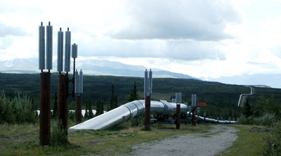
The Trans-Alaska Pipeline travels 800 miles from Barrow to Valdez. From Fairbanks south, it roughly follows the Richardson Highway, which we drove along. It's buried in places, but is elevated in areas where the high temperature of the oil would cause problems (because it would thaw the permafrost). Driving along the highway, you'll suddenly see this long silver pipeline snaking across a hill. It's odd, especially in places where there's really nothing else, including powerlines.
Here, the pipeline went underground to cross the road, and is coming back up again. There are big fins sticking out of the ground to vent the heat where the pipeline is buried, and aboveground, a complicated system of fittings to allow the pipeline to move on its supports in the event of an earthquake or the expansion and contraction due to the annual temperature extremes. You can see how the pipeline snakes through the spruce forest.
Speaking of spruce, there are a couple of kinds as far as I can tell. One has the shape of a "classic" spruce -- Christmas tree-like -- and the other is like a pipecleaner. They're wacky looking! Sometimes they're bigger at the top than the bottom, but mostly they're the same, very thin, size all the way up. It appears that if the top gets lopped off, several more sprout in its place, so it's not uncommon to see a pipecleaner tree with 5 tops seemingly jammed on the end.

<<

<

Current

>

>>