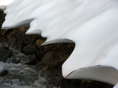
About 6:30, we hit a large stream on a steep hillside. It wasn't flat along the lake anymore, so we dropped our packs and hiked up the stream to find a place to cross. We went almost all the way up to the source (which wasn't that far, because it was quite steep), passing this undercut bank of snow on the way. After scouting out a route up top, we came back down and then decided to cross down low, where our packs were, because there was a glacier to cross just after that and we thought we'd be crossing it low.
We hopped our way across the stream and went around the ridge, and discovered that the moraine was pretty impressive down low. We took an oblique angle up the moraine, though, and got up to the moraine ridge, only to discover that it was REALLY STEEP on the other side. The glacier had also spawned a large stream that would require multiple major crossings, so we did the only sane thing (right?) -- we hiked up the moraine to the upper part of the glacier.
By now, it's after 8, and the sun sets at a bit after 9, with a couple of hours of usable light after that. We realized that this hike was going to be a lot longer than 2 hours about the time that we really should have been pitching our tent. We hadn't even been able to see the glacier until we got to the top of the moraine, so we had no idea what we were up against.
The moraine ridge was quite narrow (perhaps a foot wide at most), and quite sandy, so the surface didn't feel as stable as I would have liked. We did see that a lone bear had also traveled the length of the ridge in the opposite direction at some point, so we hoped that if a bear could walk it safely, so could we.

<<

<

Current

>

>>